Southern Fells · Book 4
Scafell
Scafell is a Wainwright, one of the 214 Lake District fells in Alfred Wainwright’s Pictorial Guides. At 964 m (3,163 ft) it is the 2nd highest of the 214 and the 2nd highest in the Southern Fells.
- Height
- 964 m
- 3,163 ft
- Rank
- 2
- of 214
- In area
- 2
- of 30
- Difficulty
- Difficult
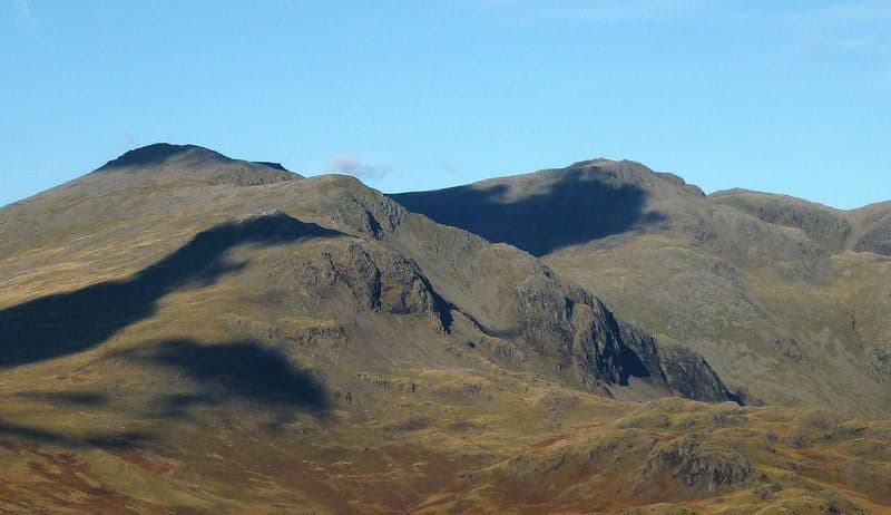
Photo: Karl and Ali via Geograph, CC BY-SA 2.0
About Scafell
Scafell sits just south-west of its higher neighbour and feels wilder and more severe. Green How is the safest way up, and the routes by Mickledore and Foxes Tarn bring steep scree, crags and short hands-on sections. Lord's Rake, the old classic, has been unstable since rockfalls in 2002 and 2016. On a clear day the view over Wasdale is superb, and in clag this complex ground calls for careful navigation. A serious mountain day with a compact, rocky summit.
Only Mickledore separates Scafell from Scafell Pike, but the direct link, Broad Stand, is a rock climb that has injured plenty of walkers. Plan your line before you set off.
Most people start in Wasdale, at the National Trust pay and display car park at Brackenclose by the head of Wastwater, or on Wasdale Head green. From there you have three real choices. Green How is a long, steep grass and stone slog straight up from Brackenclose with no scrambling, and it is the safest way up and down. The classic route follows the Scafell Pike path up Brown Tongue into Hollow Stones and then climbs Lord's Rake, a scree chute under Scafell Crag. Rockfalls since 2002, and the collapse of the block at its head in 2016, mean current guides steer walkers away from it. The third option crosses Mickledore, drops a short way on the Eskdale side, and scrambles up a gully beside a stream to Foxes Tarn, one of the smallest named tarns in the Lakes. From the tarn a loose scree path finishes the climb. Eskdale walkers come up from Boot over Slight Side.
The summit is a big cairn on a short rocky ridge. Symonds Knott, the slightly lower north top, stands just beyond it above the cliffs. Botterill's Slab on Scafell Crag, just below, was first climbed in 1903.
Coleridge on Broad Stand
On 5 August 1802 Samuel Taylor Coleridge came down from this summit towards Mickledore by lowering himself over a series of ledges. He described it in a letter, and it is often called England's first recreational rock climb. Broad Stand is now treated as a rock climb and is usually roped.
In winter
Lord's Rake and the Foxes Tarn gully both hold hard snow and ice well into spring, and the rake's loose floor is worse when frozen. Green How is the only line from Wasdale that stays a walk in winter, and even that needs crampons on the upper slopes.
- Great Views
- Potentially Dangerous
- Popular
- Scramble
Sources: Wikipedia: Scafell, Walk Lakes: Scafell Pike and Scafell via Foxes Tarn, Ronald Turnbull: Coleridge's nine-day tour of 1802. Updated .
Summit
- OS grid ref
- NY 206 064
- Latitude
- 54.44748° N
- Longitude
- 3.22470° W
- Area
- Southern Fells
Walking up Scafell
The nearest car park on foot is Lake Head Car Park, 3.2 km (2.0 miles) from the summit along mapped paths. Directions to the car park
Route from Lake Head Car Park
- Distance
- 3.2 km
- 2.0 miles, one way
- Ascent
- 892 m
- Total climb to the summit
- Time up
- 2 h 2 min
- Allow 1 to 3 hours
Times use Naismith’s rule, 5 km/h on the flat plus extra time for the climb, with Langmuir’s corrections. It’s a rule of thumb for the way up only, so add stops, weather and the walk back down.
The route follows paths mapped by OpenStreetMap contributors and isn’t a guided line. Check the mountain forecast before you go and carry a map and compass.
Scafell questions
Is Scafell a Wainwright?
How high is Scafell?
Where do you park for Scafell?
How long does it take to climb Scafell?
How hard is Scafell?
Which Wainwrights are near Scafell?
What is the grid reference for the summit of Scafell?
Often walked with Scafell
Fells people usually take in on the same day.
Scafell in our guides
Wainwrights near Scafell
Straight-line distance and direction from the summit.
 Scafell Pike978 m1.1 km NE
 Slight Side762 m1.5 km S
 Lingmell807 m1.7 km N
 Great End910 m2.8 km NE
 Esk Pike885 m3.1 km E
 Allen Crags785 m3.6 km NE
More in the Southern Fells
- Scafell Pike978 m
- Great End910 m
- Bowfell903 m
- Esk Pike885 m
- Crinkle Crags (Long Top)859 m
- Lingmell807 m
- Coniston Old Man802 m
- Swirl How802 m
- Brim Fell796 m
- Allen Crags785 m
- Great Carrs785 m
- Glaramara783 m
- Dow Crag778 m
- Grey Friar773 m
- Wetherlam763 m
- Slight Side762 m
- Pike o'Blisco705 m
- Cold Pike701 m
- Harter Fell [Eskdale]654 m
- Rossett Pike651 m
- Illgill Head609 m
- Seathwaite Fell601 m
- Rosthwaite Fell (Bessyboot)551 m
- Hard Knott549 m
- Whin Rigg537 m
- Green Crag489 m
- Lingmoor Fell470 m
- Black Fell323 m
- Holme Fell317 m
Bag Scafell with Upfell
Reach the summit and capture Scafell, even with no signal. It goes on your round of the 214 with its own patch.
Coming soon to theApp Store